Life on the Open Road (April 2006 - May 2008)

The continuing saga of a single fulltime RVer who travels the western US. This is part one of my journey, from April 2006, when the blog started, to May 2008, when the blog continues at www.lifeontheopenroad.blogspot.com

My Photo
Name:

I have been a full-time RVer for 20 years, primarily "boondocking," camping free without hookups, in the Western US. My batteries are charged solely by solar panels. I welcome your comments and emails. I also make trips to other countries, although not usually with the RV.

Thursday, April 27, 2006

Zion National Park


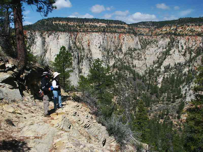
We moved on to Zion and parked 5 miles east of Virgin, UT at a little piece of BLM land along the Virgin River, just west of MM 24 on Hwy 9. I talked Barbara and Ron into doing a hike I’ve wanted to do for a while. It involved hiking 5 miles one-way from the top of a ridge, dropping 2000 feet down through Echo Canyon to the valley from an obscure trailhead on the east boundary of the park. Since Randy had a sore foot, we had ourselves a shuttle-man!

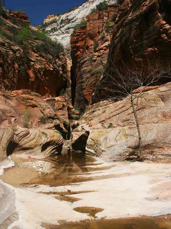
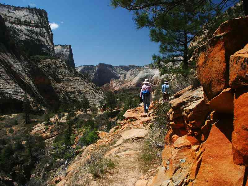
The first part of the hike was level, through a forest of pinyon and juniper with a few ponderosa pines. Then came the hard descent down into Echo Canyon. This part was steep and rocky. The prettiest part was probably going down through Echo Canyon, not too steep, meandering through a narrow crevice and some very pretty rock formations. The last part was a lot of switchbacks down to the valley floor and the park bus that took us back to the visitors center and our "shuttle-man."

Although 5 miles of downhill sounds easy, it’s hard on your knees! But it beats climbing and I was glad I did it.

Diana

Wednesday, April 26, 2006

The Wave (Finally)


Apparently, we are not very lucky people, because it took us five days to get a permit. (A record, they said!) But we finally did, and it was well worth the wait. The Wave is probably the most photogenic rock structure in the world. It was carved entirely by wind. In the early 1990s, a movie was made here that was shown in Germany. That started a stampede of photographers, forcing the BLM to limit the number of visitors, in hopes of preserving the fragile structure. Information on how to get a permit, as well as maps and directions on how to reach the Wave, are available on the Internet. http://www.dankat.com/swhikes/wave.htm is especially helpful.
It’s a sandy and rocky 3-mile hike to the Wave, from the Wire Pass trailhead on House Rock Valley Road, 8 miles south of Hwy 89. Along the hike, there are many beautiful rock formations, including lots of teepee-looking cones. But they are only a warm-up for the Wave. The Wave itself is not very large, but out of this world. There are also some other interesting swirls, "brain rocks" and even a rock that looks like a hamburger in the immediate vicinity. I took so many pictures, it’s hard to pick which ones to post, but I chose some with Barbara and Ron in them so you can get some idea of the size. Don’t they pose well?

Diana

Paria Movie Set and Old Pahreah Town Site


Still no permit for the Wave, and more people showing up every day wanting them. Pretty depressing.... But, there’s lots to see and do in the area. We decided to drive out Paria Road to see the old Movie Set and the very old town. Turns out the Movie Set was rebuilt in 1999 after a flood in 1998, so it was pristine. Movies, such as "The Outlaw Josie Wales" were filmed here, as well as episodes of "Gunsmoke" in the 1960s, because of the colorful rock background. The ghost town of Pahreah was a Mormon community founded in 1870. It didn’t last very long because of the frequent floods. There are only a couple of structures remaining. We did not realize we had to cross the Paria River to get to the old town, but Ron was nice enough to pile up some rocks so that I could get across. Fortunately, he didn’t have a camera.

Diana

Cottonwood Wash Road


We wanted to go see the Wave, a unique rock structure in the Coyote Buttes area of Vermillion Cliffs National Monument, but it is very difficult to get the required permit; only a few are given out each day, via a lottery. So we settled in at the head of House Rock Valley Road to do some other sightseeing while we waited. N37.1234 W111.9762 One day we drove up Cottonwood Wash Road, a very long dirt road through some beautiful rock formations. The road parallels the Cockscomb, a ridge of pointed rocks that look just like their name. We went all the way to Grosvenor Arch, 30 miles north of Hwy 89, stopping along the way to hike through the Cottonwood Narrows.

Diana

Sunday, April 16, 2006

Page, Arizona


After the Grand Canyon, we moved on to Page. We parked near a corral 1 1/2 miles up a dirt road across 89 from the road to Lone Rock. N 36.9956 W 111.5950

On Easter Sunday, Barbara, Ron and I went to Lower Antelope Canyon (also called the Corkscrew). It's a slot canyon that is a photographer's paradise, located on Navajo land just east of Page.

Diana

We are camped in one of the world’s great spots–the vista is 360degreesE and can’t be captured by camera. Within yards is a narrow slot canyon with walls a hundred feet high in places. The area has lots of them. Saturday night a fierce wind did its best to blow us away.

Around the corner is a movie set from the movie "Broken Arrow" starring John Travolta.

Almost within sight is the compound of the famous polygamist Alex Joseph and his six wives. You may have seen them on TV. In a previous visit here, I met him and was invited to look around. His church was a strange place indeed, sectioned off by family with his "throne" hidden behind a curtain. He gave me a paper summarizing his theological position. (Gobbledegook)

We have all these square miles to ourselves–because our rigs are so splendidly self-powered and self-contained.

A park ranger and a sheriff’s deputy have visited and chatted amiably. Neither knows exactly where the boundary is separating their respective domains.

Randy

Grand Canyon National Park


You would think that after all this traveling, we would no longer be doing touristy stuff like this. Oh well...... We had not been here for a long time. It was spectacular, of course. We stayed on forest road 307 on the east side of the park between the National Park and the Navajo Nation. It's a dirt road with lots of camp sites along it.

Sunday, April 09, 2006

Introduction


These are the adventures of Diana Tolerico and Randy Vining, journeying full-time across America, living in separate RVs. We seek out new lands, people, and experiences, boldly going where few have gone before; advancing confidently in the direction of our dreams. This blog picks up the saga in our ninth year together.
Ours is a largely "boondocking" lifestyle, camping free in remote locations. However, we are connected electronically with the world via satellite TV, radio, cell phone, and internet. Our batteries are charged by solar panels. Using a host of resources, we search out terrific free camping spots, which we intend to share with you.
We put our story on line in hopes it will be of use to you and to us. We invite your comments and inquires.